
Jefferson County Shoreline Master Program (SMP) Update
Public Hearing July 11, 2011, 6:00 PM The written public comment period for Jefferson County's response to the Department of Ecology's required and recommended changes remains open through July 25, 2011. Click here to download the DRAFT Jefferson County Response to Ecology on Changes to the Locally Approved Shoreline Master Program for your review and comment. |
 |
Jefferson County has spent the past several years updating its Shoreline Master Program (SMP), as required by the Shoreline Management Act. In doing so, the county has made the unfortunate choice of significantly increasing restrictions on the use and enjoyment of private property located on the county's shorelines. This unfairly burdens the regulated community, and carries the very real threat of reduced property values and greater control over the lives of Jefferson County citizens.
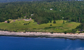
Here in Washington, shorelines of the state include all shorelines bordering salt water, as well as the shores of rivers, large creeks, and lakes. If you own one or more parcels that includes such a shoreline, you are about to face a significantly greater regulatory burden than you do today.
The provisions of the locally approved SMP update severely restrict your building, landscaping, and other activities in the 150 feet of your property immediately adjacent to the shore. Existing structures, including your home, that extend into that portion of your property become "legal nonconforming" uses. This means that the structure is still legal, but that it does not conform with the regulatory provisions of the Shoreline Master Program. This may result in financing difficulties if you wish to refinance or sell your home to a buyer who needs financing to close the deal. It may also be harder to find homeowner's insurance.
The update also designates 41% of Jefferson County's shorelines as "Natural", where after an arduous permitting process, you will be allowed to disturb a maximum of 2,500 square feet of the property to build a home. An additional 29% of the county's shorelines will be designated with "Conservation" status, where you can build a home, but most other uses require a conditional use permit. You will only be allowed to remove 20% of the shoreline vegetation for a view, and you will be required to retain 75% of the existing native vegetation.
All shoreline activities must comply with the provisions of the SMP, whether the activity requires a permit or not.
The Board of County Commissioners deliberated on and locally approved the SMP update on December 7, 2009. During the process leading up to adoption, the Olympic Stewardship's review team identified numerous significant errors and other serious problems. The issues we noted are so egregious that we reluctantly decided we needed to retain the services of a highly respected land use attorney with particular expertise in shoreline regulatory issues. Our attorney has now been working closely with us for several years on this project.
The locally approved document was sent to the Department of Ecology for review, and returned with several items targeted for required or recommended modification. The modification process is not yet complete, and the locally approved SMP update is not in effect.
The Shoreline Master Program update process has generated a great deal of correspondence and files. We've provided the following documents for your information and use. Please feel free to download them and keep copies for future reference.
Olympic Stewardship Foundation Documents of Interest
OSF Comment to Department of Ecology on Jefferson County Locally Approved SMP update
Hearing date set on Shoreline Master Program: July 11
The Jefferson County Board of Commissioners likely will hear comments on finfish aquaculture and other matters during a public hearing July 11 to review the changes to the county's Shoreline Master Program before the county seeks final approval from the state.
The hearing is scheduled for 6 p.m. in Jefferson County Superior Court. The courtoom is located inside the county courthouse at 1820 Jefferson St. in Port Townsend.
"This is a response to the state's recommended and required changes," said Stacie Hoskins, the county's planning manager.
In addition to the public hearing the commissioners are taking written comments until July 25.
"I'm really looking for qualitative comments," said Jefferson County Comissioner David Sullivan. "It's the high quality input that we're needing."
To view the proposed changed to the county's locally approved shoreline master programs, go to: co.jefferson.wa.us/commdevelop-
ment/Shoreline_StateApproval.htm.Article published in the June 22, 2011 edition of the Port Townsend & Jefferson County Leader
Jefferson County Response to Washington Department of Ecology
On June 20, 2011, the Jefferson County Board of County Commissioners set a date for a public hearing on the county's draft response to the Department of Ecology for final approval of the Shoreline Master Program update. The public hearing will be held July 11, 2011 at 6:00 p.m. in the Jefferson County Superior Courtroom at the Jefferson County Courthouse. A public comment period is open from June 22, 2011 through July 25, 2011.
Department of Ecology Review Process Documents

Locally Approved Shoreline Master Program Update